聖海倫斯火山壯觀的噴發影像

1980年的噴發序列徹底改變了聖海倫斯山周圍的地貌。地質學家蜂擁而至,進行測量和調查,在此過程中拍攝了數千張照片。我正在收集其中一些最佳照片,以供您欣賞

加入我們的科學愛好者社群!

本文發表於《大眾科學》的前部落格網路,反映了作者的觀點,不一定反映《大眾科學》的觀點


我給你們帶來了一些精美圖片,我親愛的火山愛好者們。我一直在瀏覽美國地質調查局 ScienceBase 目錄,整理 1980 年聖海倫斯火山噴發事件的影像。我發現了一些令人驚歎的照片,我們將會在“災難”系列繼續深入探討其中許多照片。但我迫不及待地想分享,所以這是第一批照片,之後還會有更多照片向你們襲來,同時我會興奮地尖叫。是的,我對火山爆發的結果感到如此興奮。

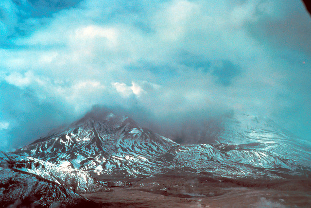
這張照片是在 5 月 18 日噴發一週後拍攝的。哇,太棒了,對吧?

Image shows the hollowed-out remains of Mount St. Helens after the debris avalanche and eruption that removed nearly 2,000 feet of its summit. New snow has fallen, dusting the barren volcanic deposits. Partly cloudy skies blend into the steam rising from the empty crater. There is no dome yet.
聖海倫斯山方向,橫跨精靈湖的傾斜鳥瞰圖,拍攝於噴發一週後。低雲覆蓋。華盛頓州斯卡馬尼亞縣。1980 年 5 月。影像和說明由美國地質調查局提供。


關於支援科學新聞報道

如果您喜歡這篇文章,請考慮透過以下方式支援我們屢獲殊榮的新聞報道: 訂閱。透過購買訂閱,您正在幫助確保關於塑造我們當今世界的發現和想法的具有影響力的故事的未來。


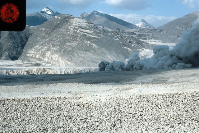
聖海倫斯火山浮石平原的絕佳景觀。這張照片拍攝於 1980 年 5 月 23 日。

Image shows a pale gray, nearly flat expanse of rocks and ash in the foreground. Beyond it, a gully can be seen just before bare ridges and mountains rise, dusted with gray ash and white snow. From the right, a pyroclastic flow is rolling across the pumice plain in the middle of the photo.

從浮石流的北部拍攝。溫度站點 PT5-18-PF81,聖海倫斯山。華盛頓州斯卡馬尼亞縣。1980 年 5 月 23 日。影像和說明由美國地質調查局提供。

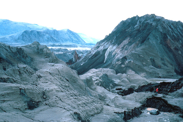
這張照片將讓您感受到火山碎屑崩塌的規模。裡面某個地方有一個成年人。

Image shows enormous mounds of rocky debris from the summit of Mount St. Helens, dusted in gray ash. To the left, there is a light brownish-gray pile of dirt and rock in the shape of a low ridge. To the center right, there is a huge mound of darker gray debris with a ragged white strip in the center. Parts of the valley are visible in the background, with the ridges bounding the Toutle River valley beyond. In the right foreground, a tiny human in a red coat is walking on the debris flow near short black cliffs.

聖海倫斯火山的火山碎屑崩塌沉積物。前景中為唐·斯旺森,作為比例尺。華盛頓州斯卡馬尼亞縣。1980 年 5 月 22 日。

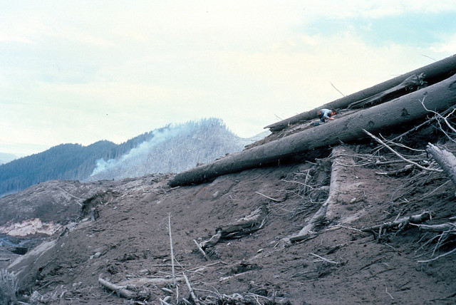
這張照片非常出色,展示了前景中 5 月 18 日噴發的碎屑。請注意作為比例尺的地質學家。在遠處山坡上,您可以看到橫向爆破摧毀森林的地方。看到它停止的地方的界線有多麼清晰嗎?這是噴發兩天後:我不確定燃燒的火焰是由爆炸引起的還是之後開始的。

Image shows a pile of huge trees, stripped of their branches, stacked on top of a pile of tree pieces and volcanic debris. The human crawling around on top of the logs is dwarfed by their size. Beyond is a mountaintop: half of it has been stripped of trees, then there is a standing line of singed trees before the destruction ends and healthy forest covers the rest of the mountain. There is smoke rising from a small fire in the center.

圖特爾河支流南叉的聖海倫斯火山碎屑。背景中為地質學家,作為比例尺。華盛頓州考利茨縣。1980 年 5 月 20 日。影像和說明由美國地質調查局提供。

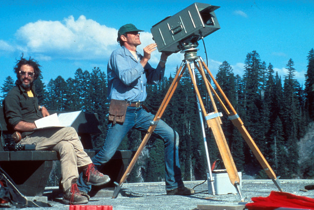
這看起來像是一張 80 年代的魅力姿勢照。但實際上是非常嚴肅的科學工作。
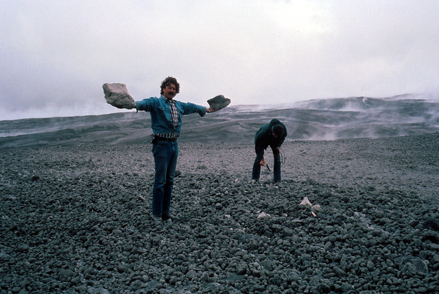
Image shows two geologists manning a geodimeter station. There is a line of conifers in the background. The geologist on the right, a dark-haired man with a beard, wearing a dark gray work shirt and khaki trousers with hiking boots, is sitting on a bench with his legs crossed, holding a folder with a page blowing over his hand. His hair is being tossed by the breeze. He is looking at the camera and smiling, looking very fly with his aviator sunglasses. The geologist next to him is wearing a blue workshirt and blue jeans, with a leather pouch hanging from his waist. He is standing in a very dramatic pose behind a piece of equipment mounted on a tripod which basically looks like a metal box with a flap lifted from the front. The man has a clean-shaven, jutting chin and looks almost like a blue-collar superhero. The whole scene gives off an almost Zoolander vibe.

美國地質調查局人員使用測距儀測量聖海倫斯山北坡的變形。華盛頓州斯卡馬尼亞縣。1980 年 5 月 4 日。影像和說明由美國地質調查局提供。

老兄,這真是非常大的浮石。

Image shows a couple of geologists investigating the pumice plain. The one in the foreground is standing with his arms held out parallel to the ground, holding two huge chunks of pumice in either hand. He is wearing blue jeans and a plaid shirt with a denim shirt tied at the waist over it. The man behind him is dressed all in dark colors and is bent over putting a temperature probe into the deposits.

聖海倫斯火山的浮石。華盛頓州斯卡馬尼亞縣。1980 年 5 月 21 日。影像和說明由美國地質調查局提供。

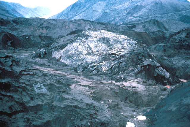
所以,萬一你想知道當火山崩塌並帶走冰川時,它看起來是什麼樣子,就是這樣

Image shows an enormous dome of ice half-buried in debris avalanche deposits. It's cracked and dusted with gray ash. Beyond it, a ridge shorn of trees rises, a logging road winding along it.

聖海倫斯火山火山碎屑崩塌沉積物中的大冰塊。華盛頓州斯卡馬尼亞縣。1980 年 5 月 22 日。影像和說明由美國地質調查局提供。

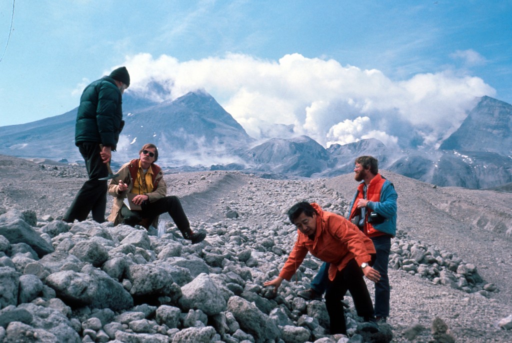
喜歡這張照片,幾位地質學家站在聖海倫斯火山的火山灰流上(嗯,照片描述說是火山灰,但對我來說更像浮石)。你能想象有這樣的工作嗎?

Image shows four geologists gathered on a jumbled pile of pumice. Two of them on the left are talking to each other. One on the right is watching those two, while the fourth man is leaning down to grab a bit of pumice. In the background, Mount St. Helens sits in clouds of steam.

地質學家在聖海倫斯火山 5 月 25 日的火山灰流上。華盛頓州斯卡馬尼亞縣。1980 年 5 月 30 日。影像和說明由美國地質調查局提供。

希望您喜歡我們的第一期。敬請期待更多!如果您迫不及待,請在 Facebook 上關注我,我在那裡一直在釋出這些照片。

© .