壯麗的聖海倫斯火山照片,第七部分

火山攝影的更多冒險

加入我們的科學愛好者社群!

本文發表於《大眾科學》的前部落格網路,僅反映作者的觀點,不一定代表《大眾科學》的觀點。


這是我在瀏覽美國地質調查局(USGS)照片資料庫時為您找到的更多精彩內容。5月18日及其後的時期為我們提供了非常壯觀的攝影機會,我們還有很長的路要走才能盡情欣賞所有這些照片。

這是早期繪製的描繪聖海倫斯火山造成的破壞的地圖中,較為令人鼓舞的一幅。

Image is a map of mudfloows, tree blowdowns, the debris flow, and ash flows. The map is mostly watercolor shades of greens and greenish-blues, with a bit of brown, tan and red.
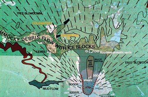
聖海倫斯火山的地貌和沉積物地圖。地圖作者:J. Moore。圖片和說明來源:USGS


關於支援科學新聞

如果您喜歡這篇文章,請考慮透過以下方式支援我們屢獲殊榮的新聞報道: 訂閱。透過購買訂閱,您將幫助確保未來能夠繼續講述關於塑造我們今天世界的發現和想法的具有影響力的故事。


5月18日聖海倫斯火山爆發。我非常著迷於火山頂部被切掉的切面是如此筆直。除了北部的缺口,這幾乎就像有人用大砍刀削掉了山頂。我希望在專業論文1251的其餘部分中,有人解釋了原因。

Image shows the shorn-off summit of Mount St. Helens with a huge column of ash boiling up into the sky. It looks like a monochrome image because the ash has shut out the sun and turned everything various shades of gray.
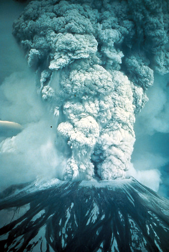
1980年5月18日爆發的傾斜航拍圖,火山灰、蒸汽、水和碎屑被噴射到60,000英尺的高度。這座山的高度降低了1300英尺,損失了約三分之二立方英里的物質。請注意從羽流中心向下流動的物質,以及火山碎屑流在火山左側山坡上的形成和移動。照片作者:奧斯汀·波斯特。華盛頓州斯卡馬尼亞縣。1980年5月18日。圖片和說明來源:USGS
 

這是一張聖海倫斯火山被截斷的山頂的相當不錯的照片,顯示了所有冰川的位置。當火山爆發時,這些可憐傢伙基本上被斬首了。

Black and white image shows the truncated summit of Mount St. Helens, with the notch in the north rim to the left. Notations and arrows point to the former locations of Forsyth, Nelson, Ape, and Shoestring glaciers along the rim.
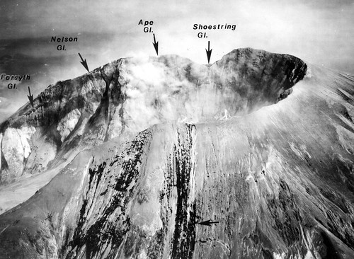
5月18日火山爆發後火山口邊緣的航拍圖。遠處邊緣上方的箭頭指示了福賽斯冰川、尼爾森冰川、猿人冰川和鞋帶冰川(從左到右)的暴露橫截面。近處山坡上的水平箭頭指示了典型的細溝和小道,它們穿過火山灰沉積物進入坡積冰川(注意冰川下游的裂縫)。左側的深色(潮溼)條紋表示被火山灰覆蓋的圖特爾冰川。照片8059-115,作者:奧斯汀·波斯特。華盛頓州斯卡馬尼亞縣。1980年7月24日。《美國地質調查局通告》850-D,1981年,圖7。圖片和說明來源:USGS
 

爆炸沉積物中一些絕對令人賞心悅目的侵蝕景象。看看那些被挖掘出來的巨大樹木!

Image is an aerial view looking down on on a sizeable erosion channel stretching from the lower left to middle right of the photo. Another channel crosses its end, making a T. Two geologists stand on the bank of the first channel, looking down at the enormous tree trunks lodged in the debris, revealed by the erosion. One of them has made a bridge.
爆炸沉積物中一些絕對令人賞心悅目的侵蝕景象。看看那些被挖掘出來的巨大樹木!圖片和說明來源:USGS
 

大家都會很高興知道,儘管我已經用盡了原始搜尋詞的結果,但我透過使用不同的搜尋詞又發現了大約一千張照片。所以大家在一段時間內都會繼續看到聖海倫斯火山的照片。

Color image shows a tall mound of volcanic debris with a cirque-like channel carved in it. Water is gushing from the talus three-quarters of the way down. A man in jeans and a t-shirt is standing beside the spring, looking toward the camera with his hands on his hips.
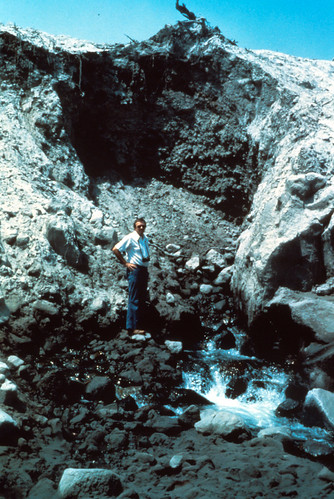
爆發後不久,水流過泥石流,並在峽谷的溪流處以泉水的形式湧出。這些水清澈而冰冷。您會注意到泥石流的層序以及沉積在各處的碎屑。圖中有人物作為比例尺。華盛頓州斯卡馬尼亞縣。1980年。圖片和說明來源:USGS
 

雪崩百合生長在侵蝕到火山沉積物中的溝渠中。令人驚歎的是,這些脆弱的小東西竟然能在如此巨大的破壞中茁壯成長。

Image shows a bank of dark gray ash. Erosion has carved a shallow, sinuous channel in the ash. Lovely white avalanche lilies are growing in the channel, their green leaves vivid against the gray.
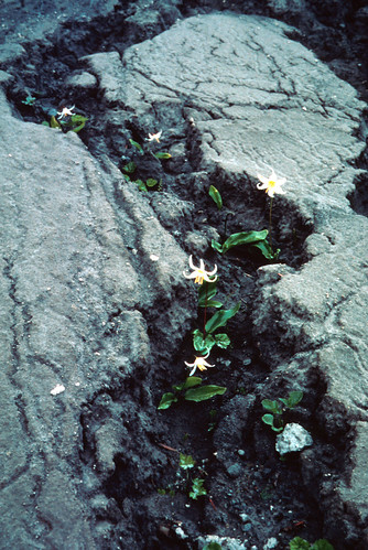
雪崩百合在聖海倫斯湖北岸盛開,位於聖海倫斯火山以北。華盛頓州斯卡馬尼亞縣。1980年6月20日。圖片和說明來源:USGS
 

以往版本:123456

© .